Alamere Falls Hike
Where: Alamere Falls, , Point Reyes
Difficulty: Moderate - 7.5 miles round trip
Beauty: 10/10
Leader: Carl Koskey 510.953.2001
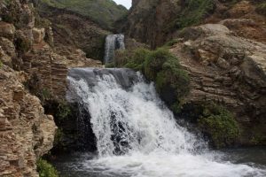
At only a few places along the California Pacific Coast, waterfalls flow directly into the ocean. Here at Point Reyes National Seashore, Alamere Falls is accessible only on foot. At high tide, the surf reaches the base of the falls.
This trail starts at the Palomarin Trailhead and continues along the Coast Trail to Bass Lake, (perfect for a dip). We’ll reach Alamere Creek and take an unofficial trail to a series of plunge pools. We’ll then climb down the bluff to the beach where the falls cascade into the Pacific. After lunch and a walk on the beach, we’ll head back along the same trails to the Palomarin trailhead for a return home.
For complete details visit the following websites:
https://www.bahiker.com/northbayhikes/palomarin.html
https://www.nps.gov/pore/planyourvisit/upload/map_park.pdf
Directions to Trailhead:
From Highway 101 in Marin County, exit Highway 1/Mill Valley/Stinson Beach. Drive on Shoreline Highway to the junction with Almonte, about 1 mile. Turn left on Highway 1 and drive about 2.5 miles to the junction with Panoramic. Continue straight on Highway 1 about 13 miles to an unsigned junction with Bolinas-Fairfax Road (just past Bolinas Marsh/lagoon). Turn left. Drive 0.1 mile to the T intersection, turn left on Olema-Bolinas Road toward the town of Bolinas, drive about 1 mile to the junction with Horseshoe Hill Road, and turn left. Drive about a half mile to the next stop sign, and turn right onto Mesa Road. Drive about 4 miles, then continue the last 1 mile on the dirt road to the trailhead at the end of the road.